Hindoostan

Reading my blogging friend Arv’s latest (excellent) blog on Jaipur, I was reminded that the area that is now the state of Rajasthan was originally called Rajpoot, the area comprising a mix of princely states. This sent me to look at an old encyclopaedia I have – volume two of the 1848 / 1849 Chambers Encyclopaedia. Things were rather different back then, in the days of the British Raj – a complex history I won’t go into here, especially since I know a number of my readers are already familiar with it. But from that volume, here is the map of India, or Hindoostan as it was usually known by the West, although it was occasionally referred to as India and sometimes as the East Indies.

Obviously, the countries of Pakistan and Bangladesh were still part of this country as this was long before Independence. Indeed, this was even before the First War of Indian Independence, also referred to as the Indian Mutiny, in 1857.

There is a lot that can be learned from old encyclopaedias, especially about the attitudes the west had towards other parts of the world, which make for uncomfortable reading today. But again, I don’t propose to go into that now, rather just leave this map here for interest.

But for anyone who has ever struggled with the conversion rates of currency when they have travelled, this extract might bring a wry smile. The circulating medium of India consists of gold and silver coins, paper-money and cowries. The most common silver currency is the new coinage of Calcutta…Cowries are small shells which, not being depreciable by imitation, form a good medium for buying and selling among the lower classes. Their value varies in different places. The following is their value in Calcutta:-4 cowries 1 gunda; 20 gundas 1 pon; 32 pons one current rupee, 0r 2s. sterling (2560 cowries); 10 current rupees £1 sterling. The sicca rupee is 16 per cent less in value than the current rupee, which is an imaginary coin. The Bombay rupee is valued at 2s. 3d.; a pagoda is 8s.

Good luck trying that one in your head in the marketplace.

Southern India (2)

trichy skyline 2

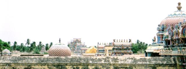
Another shot of the skyline of Sri Ranganathaswamy Temple in Trichy.

trichy temple door

Decorated door in the Sri Ranganathaswamy Temple.The scorch marks at the foot of the door are from candles and incense sticks, which have been lit and offered to the god in pujas.

shore temple

Shore Temple, Mamallapuram. Mamallapuram is a short way South of Chennai (Madras) and is a large village which is home to hundreds of stone sculptors. The village itself has a wealth of old temples and sculptures in the form of friezes and ‘Rathas’ – literally chariots, carved out of solid rock. The Shore Temple shown here has been extensively weathered by wind and sea, but has a remarkable amount of detail still preserved.

5 rathas elephant

Carved Elephant at the 5 Rathas, Mamallapuram. An incredible complex of rock-cut temples from the Pallavan Period, 300m from the shore. They were buried under the sand until rediscovered and excavated by the British some 200 years ago.

side street

Sometimes it seems that there is a temple down every side-street. This one is in a village near the town of Dindigul, Tamil Nadu.

roof shrine

This roof shrine is nearby.

salt-workers

Salt workers pose for a photograph at the salt pans near Marakkanam, just north of Pondicherry (now renamed Puducherry, its original name before the French arrived). The sea is allowed to flow into ‘pans’ (not unlike paddy fields!) and then evaporates over several days under the hot sun, leaving behind a layer of salt which is gathered by hand. Salt has been gathered this way in India from time immemorial, but when the British in India imposed a salt tax, this eventually led to the ‘Salt March’ led by Gandhi, where he symbolically gathered salt at the coast after a 200km march, an action that contributed to the loosening of the hold that the British Raj held on India.