The Long Man of Wilmington…

You have met before.

I’ve posted about him in the past in connection with the musical suite On Windover Hill by Nathan James, but here he gets to star in his own blog post.

There is a fine day’s walk to be had from Polegate, just north of Eastbourne, with a handy railway station, along to Folkington, then up onto the Downs and along past the Long Man and down to Alfriston. From Alfriston there is a very pleasant walk along the Cuckmere river to Litlington where one turns north and, after stopping briefly – say for about an hour – at Church Farm where the Long Man brewery is located, head east back up onto the Downs and another four or five miles back to Polegate, passing through Lullington Heath nature reserve (which always seems to feel a little wilder than most other parts of the Downs, or perhaps that’s just the weather I’ve encountered when I’ve passed that way) to Jevington, then along a mixture of roads and footpaths to finish. It’s a full day’s walk, but well worth the effort.

He’s called the Long Man of Wilmington, or the Wilmington Giant, although he sits on the side of Windover Hill.

The Long Man is a figure cut into the chalk of the South Downs, similar in that respect to the more famous Uffington White Horse and the Cerne Abbas Giant. Like those two figures it is not known when exactly this one was cut, but unlike them it is fairly certain it was comparatively recent. The first known mention of the Long Man was in an illustration drawn in 1710 when he also boasted a face and what looks as though it might be a helmet on the top of his head. It will be noticed that the position of the feet has changed through the years, too, although not dramatically.

I say he is cut into the chalk, although these days the outline is composed of bricks painted white sitting in the hollows of his outline.

The Long Man stands on the scarp slope of the chalk directly facing the village of Wilmington. On the edge of the village nearest him, there are the remains of a fourteenth century priory. It seems difficult to attach much significance to that, although it has been suggested he might have first been created by the monks to while away some idle time. I have to say, I didn’t think monks had that much spare time, though.

There is also a school of thought that thinks the Long Man is actually a Long Woman, suggesting the proportions of the body back this up. Personally, I don’t see this, either.

I’m very curious about the origin of the name Windover Hill itself. It is marked on the 1874 six inch Ordnance Survey map as Winddoor Hill, and in 1779 referred to as Windore Hill. Before this, I believe it was called Wyndore Hill, possibly from the Anglo-Saxon Wind Ora – windy bank. Another possibility involves an old name for the kestrel, which is Windhover, and there are certainly kestrels along the South Downs.

There are a number of theories about the two poles held in the figure’s hands. They would appear to be staves or poles of some sort, and it seems obvious that they were of some significance when the figure was cut. A 1776 drawing shows him with a scythe and rake, although this seems highly unlikely given that the 1710 drawing does not show this.

However, a resistivity survey done in the 1960’s does show disturbance around the tops of the staves, which might indicate either that the staves were originally longer than they are now or that there could even be some truth in the scythe and rake picture. It is always possible these had been added post 1710, I suppose. In 1925 Alfred Watkins published The Old Straight Track, in which he first proposed his theory of ley lines. Although maybe I’ll go into more detail about these another time, the essence of the theory is that many natural features of Britain are connected by invisible lines of power, and that ancient features such as standing stones or burial mounds, as well as more recent features such as churches and castles, were built on these invisible lines as a way of tapping into this power. Watkins talks a lot about how these lines would be surveyed by using two long poles as markers and mentions the Long Man in passing.

I think the jury is definitely out on that one.

Whatever the origins of the figure, though, it is certainly impressive both close up and viewed from a distance.

And another good reason to visit the area? The Long Man brewery at Church farm in nearby Litlington selling fine – nay, very fine – Sussex ales. You might have guessed I’d mention them.

In All Weathers

We’ve been on the South Downs again.

That’s why you haven’t heard from me for a while. Here’re a few pictures.

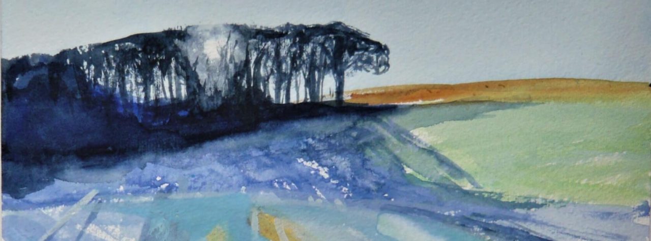
We began walking from Amberley this time, and on the first day the weather was pretty meh. It was either raining or starting to rain or just deciding when to rain. But, as always, the Downs looked fantastic. This view reminded me of a Roland Hilder painting:

But it got steadily wetter throughout the day. We took a very welcome break in the Frankland Arms in Washington and if I was writing a pub review it would get five stars – especially as it served Harvey’s Old Ale. But I only allowed myself one of those, as we still had some serious mileage to do. And it was, as noted, getting wetter. We approached Chanctonbury Ring:

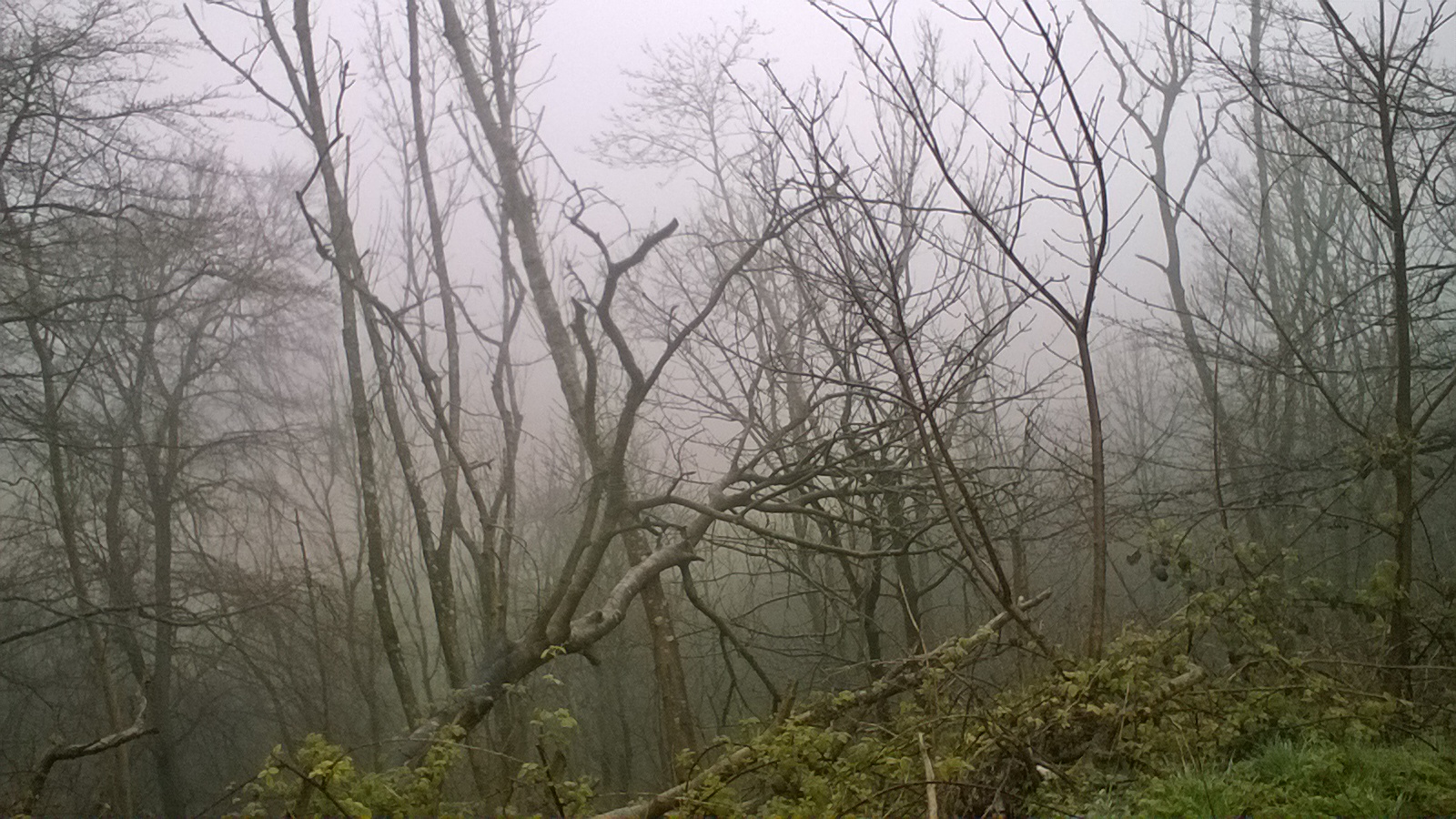
And as we began the descent from the top, the saddest part of the journey. We walked among a large number of ash trees, all of which were dead or dying from Ash Dieback disease. It looked like a picture of the Somme.

The next day was dull, but at least it was dry. We walked past the Devil’s Dyke which I never seem to be able to get a good picture of, no matter which angle I take it at. The Devil’s Dyke is so-called because for some reason the Devil wanted to destroy Sussex, and got talking to Saint Dunstan and asked him the best way to do it. Why he did that I can’t imagine. Never ask a saint for advice if you’re the Devil. It won’t end well. Anyway, Saint D suggested he dig a channel through the South Downs and flood it. Right, thought Old Nick, and set to work. Saint D let him toil away for a few hours and then caused all the cocks in Sussex to crow. Thinking it was morning, Old Nick threw down his shovel, twirled his moustaches and hissed ‘Curses, foiled again!’

Alternatively, it might have been caused by melt-water during the ice age, but why spoil a good legend?

And the best weather? During our rest day in Lewes. And, oh look! There’s the Harvey’s Brewery! What a good rest day.

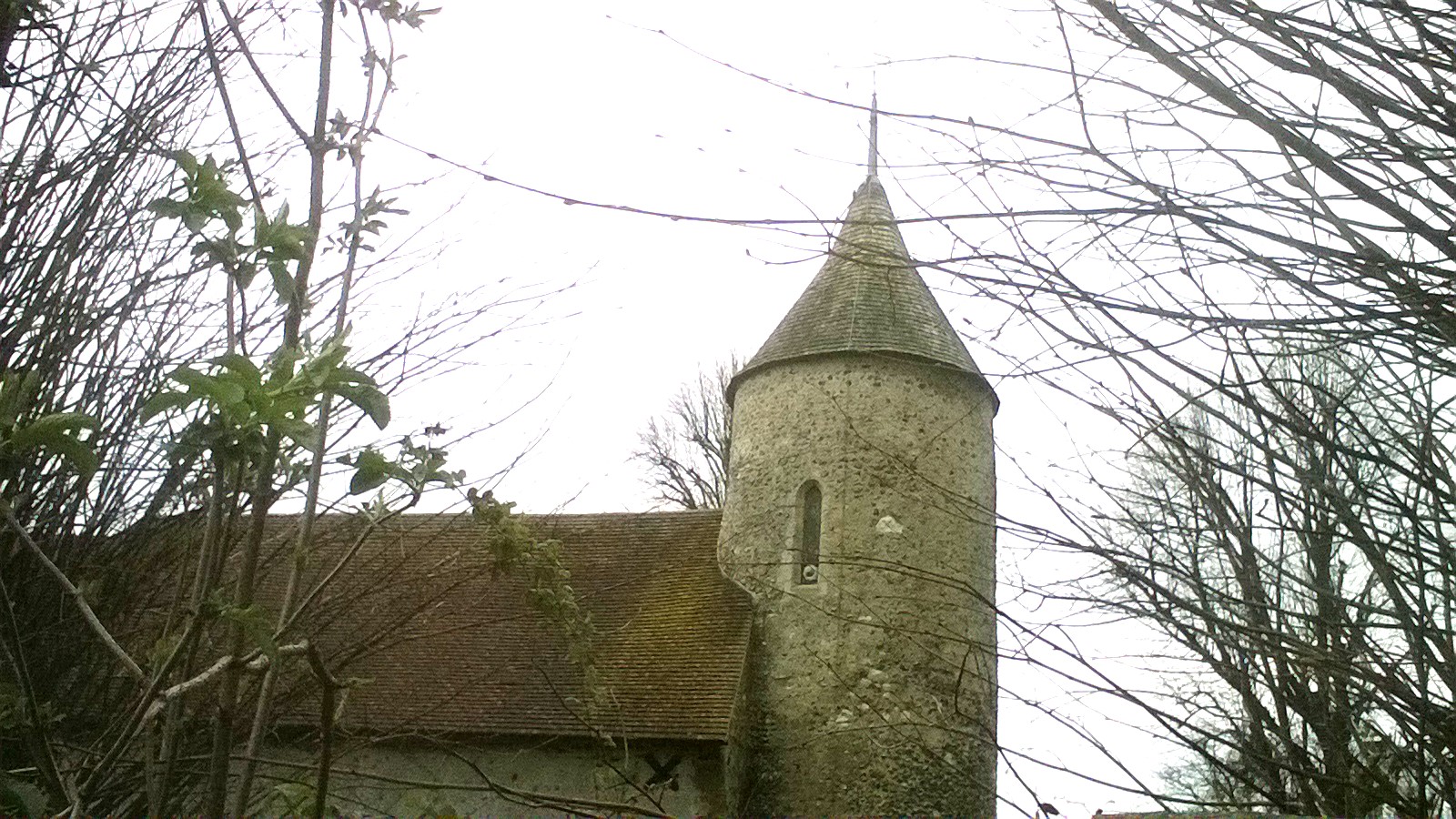
The following day was dull again as we left Lewes, and by now quite a sharp wind was blowing – into our faces too, unfortunately. But we had a pretty decent day and passed this church in Southease, one of only two (I think) in England with a round tower outside of Norfolk. The other is in nearby Lewes.

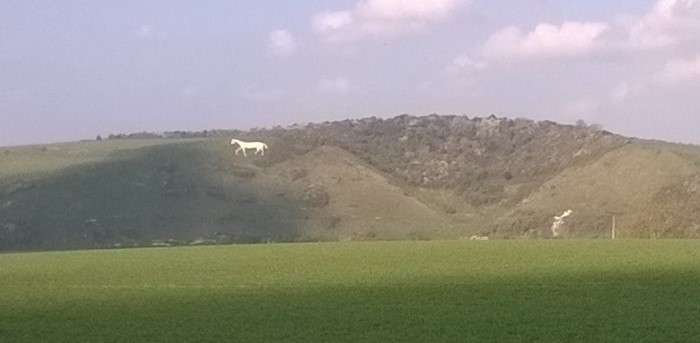
The final day began sunny but again with a sharp and unkind wind. We left Alfriston with its church on the edge of the village by the river and headed towards the coast. On the South Downs away to our right we passed a white horse carved into the chalk.

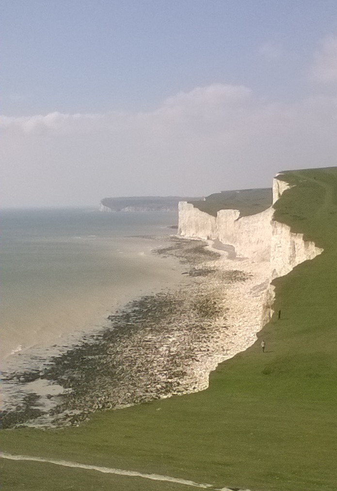
Soon we were up onto the Downs again, for the final walk into Eastbourne over the Seven Sisters and Beachy Head. I tend to forget how tiring this leg can be, going continually uphill then downhill for the best part of six miles. For some reason, although we could see the Belle Tout lighthouse in the distance, it never seemed to get any nearer. Once I could do this leg of the walk easily, but…getting a little older…

An always fantastic view, though. Here we’re looking back across the Seven Sisters towards Seaford Head.

After all that, we could do with a holiday.

Being Wistful: South Downs Way 1 – Eastbourne to Steyning

Some of my own response to the Covid-19 crisis and the restrictions we all find ourselves under is to revisit my favourite places, in books or thought, films or photographs, or even old blog posts. It is sobering and depressing to realise I may not be able to go more than a few miles from home over the coming months, but this does help a little.

The South Downs are a favourite, so I’m going to re-post this short series I put up a couple of years ago after our most recent walk along the South Downs Way:


Once upon a time, or five or six years ago, if you prefer, I thought I would start up my own outdoor adventure company. It never happened in the end, largely due to the cost of insurance. However, if I had gone through with it I have to admit it would have been largely so I could go on long distance trails both in the UK and overseas without having to pay for it.

Oh, well. It was a nice idea.

The South Downs Way is a long distance footpath of one hundred miles in length, running from Eastbourne to Winchester, or Winchester to Eastbourne, if you must, along the top of the South Downs.

Hence the name.

We walked it in May.

It is usual, when writing about a journey – especially a long distance walk – to write in some detail about the scenery and the route, in sequential order. I don’t think I’ll do that this time. Instead I’ll probably jump about all over the place writing about odd things we found particularly interesting.  And post one or two photos of the stunning scenery…

039a

Such as this one.

So, a few points of interest.

This, then, is a dew pond:

043a

Chalk is a porous rock, allowing any rainfall to rapidly soak away, so the only way of providing water on the top of the downs is by artificial means. Dew ponds have been made up there for hundreds of years; a hollow is dug and lined with clay, which then fills naturally when the rain falls. Dew is probably not a significant contributor, despite the name. The downside to this simple system is should the pond dry out, then the clay, too, will dry out. When this happens, it will shrink and crack, and subsequent rainfall will leak out.

And while on the subject of rainfall, we didn’t have glorious weather all the way:

053a

We were forced to seek refuge in a convenient pub at the Devil’s Dyke for a couple of hours, but we made the best of it. This was clearly A Good Move because although it was still pouring with rain when we eventually left the pub, it began to clear up in about an hour and then we had sunshine for the rest of the day.

008a

These are cowslips. The word comes from the Old English cuslyppe, which means cow dung, because, yes, that’s where they like to grow, apparently. Years ago, before the coming of intensive farming practices and industrial weedkillers, our fields were full of cowslips, but they seem to be met with now primarily in the more open landscapes – like downland. For the first few days of our walk, especially, we saw lots of cowslips.

We had a rest day at Steyning, although we stayed at nearby Bramber.

050a

Bramber Castle is a strange and mysterious place, which magically energises the over sixties and causes them to revert to their childhood.

Although not for long, sadly.

David Nash and Impermanence

A few days ago we went to the Towner Gallery in Eastbourne, Sussex, specifically to see the Eric Ravilious paintings and prints on permanent exhibition there. There was also a large exhibition by the sculptor David Nash, who works with wood on a large scale. The fact that the whole exhibition, which also included a gallery of paintings, prints and a couple of small installations, and was intended to highlight the effects of the Climate Crisis, was the first one ever curated by Caroline Lucas M.P. of the Green Party was an added bonus for me.

007a


002a

As much as I enjoyed the Ravilious, I was blown away by Nash’s sculptures. To see wooden sculptures on that scale is unusual in itself – usually that would be the preserve of stone or metal – but that very scale plays tricks with the mind and the eye. Boxes and bowls many times larger than one would expect meet the eye as you walk around the galleries, and many of the pieces also deceive where perhaps one looks to be made from several separate pieces of wood, but on closer inspection are carved from a single block like the boat shapes in the top picture, or the ‘stack’ in the one below that.

Much of the work is left rough-hewn, but even this can be deceptive. Some pieces have been carefully finished to give that appearance.

Sculpture is the art form that seems to exist to interact with the natural world. A number of the works here are based on natural forms, but there are also stories of projects Nash has undertaken where his sculpture is either living, in the form of carefully planted and managed groves of trees, or interact in other ways.

004a

‘Boulder’ is one such project. One of the first large-scale pieces Nash made was to cut a boulder-shaped chunk from a tree (illustrated at the top of Nash’s charcoal drawing above) in 1978. This was then transported to a stream near to where he lives and works, in the Welsh hills, and rolled into the water. Since then, it has slowly made its way downstream until it reached the estuaries and inlets of the sea, where it finally disappeared in 2015. Nash documented its travels in a series of photographs and films made regularly all the while, and presented in the exhibition as a film.

006a


003a


003b

Nash’s sketch of a Larch trunk

It feels as though there is something of this meeting of art and the natural world in old ruins overrun with scrub and grass. They frequently seem to have a sculptural quality that complements the landscape around them, in a way that more pristine buildings do not.

And I like the sense that an artwork, like a ruined building, is not permanent and that eventually the natural world will absorb it back into itself. That it will reclaim it. Perhaps the artist and the environmentalist in me merge here.

My own sculptures are in wood, and some of them are set out in our garden where they gradually degrade over the years through the action of sun and rain, until they appear strangely like some weird plants that have sprouted unexpectedly there.

The Sussex Downs Murder – Not Really A Review

24958623

For anyone who loves the English South Downs – and whodunnits – this book makes an interesting read.

On the one hand, it is a fairly average 1930’s detective murder mystery, although I have certainly read much worse, but on the other it provides some marvellous insights into the South Downs in the area specifically around Chanctonbury Ring in that time, which is really what took my interest.

Personally, I prefer murder mysteries involving ‘normal’ people, rather than the typical country house full of assorted Colonels and ladies and royalty and such-like, so popular at the time – other than the thought of bumping off the Upper Classes, of course! But this book delivers in that it is set on a downland farm, where the farmer goes missing, believed murdered. It even has, as a cover, an adaptation of one of the fabulous Leslie Carr railway posters of the 1930’s – what’s not to like?

The introduction mentions its ‘sense of place’, and the writing seems to me especially good at conveying an accurate feel of the landscape. One thing that comes over very strongly is the emptiness of the countryside at that time. The Downs have been sparsely inhabited since Roman times; before then, much of the population chose to live on the higher, drier, lands of the chalklands of South and South East England, away from the forested and frequently marshy lower areas where travel was difficult and clearance very hard work. After the arrival of the Romans, however, all this changed, and since then the chalklands have been left largely to a small population living mainly by farming sheep.

We now have many people visiting for leisure purposes and on fine days popular routes such as the walk to Birling Gap from Eastbourne (or from convenient car parks much closer!) may easily see hundreds of visitors striding along the footpaths and hanging off the edge of the cliffs taking selfies (other stupid ways to kill oneself are available). On the same day, though, nearby footpaths may see no visitors at all. It is still a sparsely populated area.

John Bude evokes this sense of emptiness well. His descriptions of the roads and paths on and around the area really allow the reader to feel this. His characters walk the lanes and roads of the downs frequently without meeting anyone else on their journeys. Farms and houses are ‘isolated’, and even at a time when most people would travel by public transport to cover any distance, the population is so small that when questioned by the detective on the case, a bus conductor can remember who was on his bus several weeks before.

There are four lime kilns near Washington, on the edge of the area described in the story, which I suspect were the inspiration for the lime kiln featured on the farm in the book. No spoilers, but you might well guess their relevance to a murder mystery.

But it is the descriptions of the roads and paths that particularly take my interest, roads and paths virtually empty of footfall or traffic even during the day, emphasising how lightly populated the area was, and still is today, to a degree. Other than popular footpaths such as the long distance South Downs Way, and those footpaths running between popular tourist spots, it is still easy to find solitude in this quiet area of the otherwise heavily populated South East England.

South Downs Way 1 – Eastbourne to Steyning

Once upon a time, or five or six years ago, if you prefer, I thought I would start up my own outdoor adventure company. It never happened in the end, largely due to the cost of insurance. However, if I had gone through with it I have to admit it would have been largely so I could go on long distance trails both in the UK and overseas without having to pay for it.

Oh, well. It was a nice idea.

The South Downs Way is a long distance footpath of one hundred miles in length, running from Eastbourne to Winchester, or Winchester to Eastbourne, if you must, along the top of the South Downs.

Hence the name.

We walked it in May.

It is usual, when writing about a journey – especially a long distance walk – to write in some detail about the scenery and the route, in sequential order. I don’t think I’ll do that this time. Instead I’ll probably jump about all over the place writing about odd things we found particularly interesting.  And post one or two photos of the stunning scenery…

039a

Such as this one.

So, a few points of interest.

This, then, is a dew pond:

043a

Chalk is a porous rock, allowing any rainfall to rapidly soak away, so the only way of providing water on the top of the downs is by artificial means. Dew ponds have been made up there for hundreds of years; a hollow is dug and lined with clay, which then fills naturally when the rain falls. Dew is probably not a significant contributor, despite the name. The downside to this simple system is should the pond dry out, then the clay, too, will dry out. When this happens, it will shrink and crack, and subsequent rainfall will leak out.

And while on the subject of rainfall, we didn’t have glorious weather all the way:

053a

We were forced to seek refuge in a convenient pub at the Devil’s Dyke for a couple of hours, but we made the best of it. This was clearly A Good Move because although it was still pouring with rain when we eventually left the pub, it began to clear up in about an hour and then we had sunshine for the rest of the day.

008a

These are cowslips. The word comes from the Old English cuslyppe, which means cow dung, because, yes, that’s where they like to grow, apparently. Years ago, before the coming of intensive farming practices and industrial weedkillers, our fields were full of cowslips, but they seem to be met with now primarily in the more open landscapes – like downland. For the first few days of our walk, especially, we saw lots of cowslips.

We had a rest day at Steyning, although we stayed at nearby Bramber.

050a

Bramber Castle is a strange and mysterious place, which magically energises the over sixties and causes them to revert to their childhood.

Although not for long, sadly.