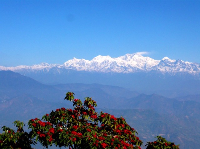
Kanchenjunga, the third highest peak in the Himalaya (and the world) taken from Observatory Hill, Darjeeling. It is the peak right of centre, with the spindrift blowing from the summit.
Have a great Thursday.
Kanchenjunga, the third highest peak in the Himalaya (and the world) taken from Observatory Hill, Darjeeling. It is the peak right of centre, with the spindrift blowing from the summit.
Have a great Thursday.
Ouch! Probably my worst title yet!
I can’t help it…I’ve not been well…
…well, only a cold, but you know what we men are like.
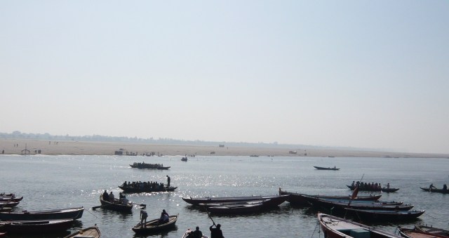
In another attempt to feel instantly better, I’ve nipped across to North India (only in my imagination, unfortunately), to picture Kedar Ghat, on the banks of the Ganges, in Varanasi.

Ghats, a Hindi word, are sets of steps leading down to a river (and also mountain ranges or passes – The eastern and Western Ghats in Central India). It has also come to mean a level place at the edge of a river where Hindus cremate their dead.
In Varanasi, there are between 84 and 87 ghats, depending upon who you get this information from,. The Manikarnika Ghat, or Ghats (possibly this is the origin of the confusion over the number) is the ‘burning ghat’, where cremations are carried out 24 hours a day, all through the year. The source fire there has supposedly been burning for thousands of years, but photography is actively discouraged, hence my only shot is one taken from a distance.

Of course, the ghats are also used for bathing. Hindus bathe en masse there, as a dip in the Ganges is meant to wash away sins. Important pujas (ceremonies) take place at sunrise and sunset. Boat trips to view the ghats are very popular, and finally much of the city’s laundry gets done at the dhobi ghats (dhobi meaning laundry).
Namaste!
It’s been a busy week again. I don’t seem to have managed to write anything, take any photographs, or even think about drawing or painting.
The news? I try to avoid it.
And to top it all, I have a cold and I feel bleurgh.
It’s at times like this I usually travel somewhere exotic in my head.
So, a few more photographs from Southern India, then.

Ganesh Temple, Kodaikanal. Ganesh, the elephant-headed god of prosperity, is one of the most popular gods in the Hindu pantheon and worshipped widely throughout India. This shrine is by the lake in Kodaikanal, a hill-station in the Palani Hills northwest of Madurai.
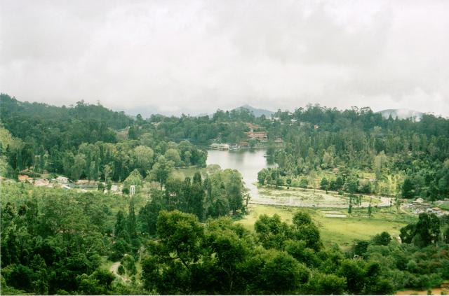
View of the lake at Kodaikanal. Besides the better known hill stations of Northern India, there are quite a number further south, of which Kodaikanal is just one example, although unique in having been originally started by American missionaries in the 1840’s.

Raj-era bungalows in Kodaikanal. These are on a ‘prime-site’ location overlooking the lake.

Madurai skyline. The Sri Meenakshi Temple complex, dedicated to Shiva and his wife, Sati, dominates the skyline of the old city. Often called ‘The Heart of Tamil Country’, Madurai attracts up to 10,000 pildrims and tourists on any one day. This picture was taken from the Rooftop Restaurant Terrace at the Hotel Supreme, where we sat with a beer and watched a long procession of tourists wander across the roof to take the same shot.

Entrance to the Sri Meenakshi Temple complex, Madurai. 12 huge gopuram towers, each between 45 and 50 metres in height, are carved in highly elaborate designs featuring gods, people, animals and mythical creatures which are then brightly painted. The whole effect is more like an enormous and eccentricly iced cake, or at least plaster-work. The whole of the temple seethes with pilgrims, tourists, trinket sellers and guides. And touts, who basically cover the last two categories.

Carved statue of Nataraja, Madurai Temple complex. I am unfamiliar with this particular god, but I like the carving!
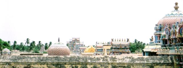
Another shot of the skyline of Sri Ranganathaswamy Temple in Trichy.

Decorated door in the Sri Ranganathaswamy Temple.The scorch marks at the foot of the door are from candles and incense sticks, which have been lit and offered to the god in pujas.

Shore Temple, Mamallapuram. Mamallapuram is a short way South of Chennai (Madras) and is a large village which is home to hundreds of stone sculptors. The village itself has a wealth of old temples and sculptures in the form of friezes and ‘Rathas’ – literally chariots, carved out of solid rock. The Shore Temple shown here has been extensively weathered by wind and sea, but has a remarkable amount of detail still preserved.

Carved Elephant at the 5 Rathas, Mamallapuram. An incredible complex of rock-cut temples from the Pallavan Period, 300m from the shore. They were buried under the sand until rediscovered and excavated by the British some 200 years ago.

Sometimes it seems that there is a temple down every side-street. This one is in a village near the town of Dindigul, Tamil Nadu.

This roof shrine is nearby.

Salt workers pose for a photograph at the salt pans near Marakkanam, just north of Pondicherry (now renamed Puducherry, its original name before the French arrived). The sea is allowed to flow into ‘pans’ (not unlike paddy fields!) and then evaporates over several days under the hot sun, leaving behind a layer of salt which is gathered by hand. Salt has been gathered this way in India from time immemorial, but when the British in India imposed a salt tax, this eventually led to the ‘Salt March’ led by Gandhi, where he symbolically gathered salt at the coast after a 200km march, an action that contributed to the loosening of the hold that the British Raj held on India.
Southern India differs from the north in several respects. The first difference that the visitor tends to notice, once they have got away from the typical Indian maelstrom of airport, traffic, city centre, etc, is that with the less densely concentrated population comes a somewhat more laid-back atmosphere and attitude than in the north. The hassles and pressures, the touts, are still there, but seem somehow less intense.
The second real difference is in the culture. Southern India was never really assimilated into the Mogul empire, and only ever partly conquered, so there is a huge wealth of Hindu architecture and a proportional lack of Islamic, with next to no Buddhist remains and no continuing tradition of Buddhism at all. At times, it seems as though the visitor has entered a different country, but India has a way of reasserting itself on the senses…

Stall outside Sri Ranganathaswamy Temple, Tiruchirappalli (Trichy), Tamil Nadu State. All over India, amongst the heat, dust and drabness that pervades the majority of the population’s day to day life, one finds colour.

Garland seller outside Rock Fort Temple complex, Trichy. The garlands will be used to decorate statues of gods during pujas (ceremonies) conducted in the Temples.

Rock Fort temple, Trichy. A view of the main temple from the pathway that leads to the tiny temple at the top of the rock. Non Hindus are not allowed into the main temple, dedicated to Shiva, or the temple at the top dedicated to Ganesh…although for a small donation, the priest is willing to waive this rule…
From my journal:
‘The trip is not particularly uncomfortable. It is a typical five hour trip through India – dust, buffaloes, half a dozen schoolchildren stuffed into an autorickshaw, wait-till-the-other-guy-blinks over-taking, temples large, medium and small, huge dry river beds, The Cauvery full of water, trees, strange crops, broken down trucks, train lines stretching arrow-straight into the distance, rows and rows of stalls with neat piles of fruit and vegetables, rows of hanging water bottles from the roof, biscuits, samozas, cigarettes and crisps, a child squatting in the dirt, mum feeding the family beneath the tree, ‘Tiffin Ready’ signs, smart petrol stations, mud huts, cement buildings, palm shacks, huge residences surrounded by high walls – all concrete, police traffic blocks (ignored), it all blurs into one.’
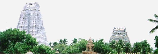
Part of Sri Ranganathaswamy Temple complex. This is the largest of all temple complexes in India, covering a staggering 60 hectares, and is dedicated to Vishnu. The Gopuram (tower) on the left is painted white, as a symbol of purity, and is one of the buildings that non-hindus are not permitted to enter.
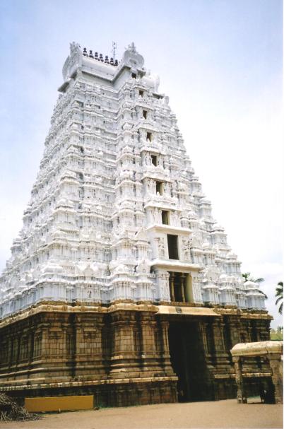
The White gopuram, in all its glory.

Pillar in Sri Ranganathaswamy Temple, liberally decorated with coloured powders and with offerings of incense, rice and flowers. Devotees of the god concerned will conduct their own personal pujas to ensure health and prosperity, or perhaps for some more specific purpose, such as to request the birth of a son or success in a particular undertaking. Although this temple is dedicated to Vishnu, other gods are represented there and prayed to.
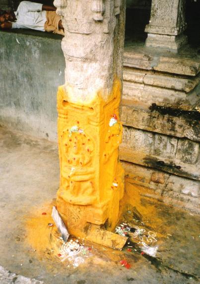
Another, nearby, pillar in the same temple. Although in the same temple and close to the pillar in the previous picture, this shrine will be to another, different, god. Its use, however, will be the same.
Long ago in the misty depths of time – that’s last year, actually, I posted a piece about Ladakh (you can find it here if you’d like to read it.)
This, then, is another mixture of photographs and entries from my journal of my 2005 trip to India, which included a couple of weeks spent in Ladakh. I went comparatively early in the year, when the nights are still extremely cold and very few visitors have made their way up from the plains.
Just the way I like it!
Ladakh is high. If you fly in from Delhi (the only way to enter Ladakh for 8 months of the year), you travel from around sea level to 3500m in no time at all. Ladakh means ‘The Land of High Passes’, and is aptly named. Leh, the capital, at 3500m, is one of the lower areas of Ladakh. It’s all uphill from there. Winters are incredibly harsh and the summer growing season brief, yet the Ladakhis traditionally are self-sufficient in everything they need – food, clothing and shelter – and have only recently collided with the western consumer society. In contrast with most of the rest of India, the religion and culture of the majority of the people there is Tibetan Buddhism.

The Roof of the World – View across the Indus valley at 3500m, Thikse, Ladakh.
Friday 8th April 2005
I’m in Ladakh and, hey, wow!
At the airport for 4.30am, to find the flight postponed until 8am, due to weather conditions. It all looked ominous, but just after 7am we were told to check in and after numerous baggage checks, body checks, baggage identifications, etc, we were away at 8.30.
I’ve heard the flight described as one of the most spectacular in the world. I’ve also heard it described as jaw-dropping. I can imagine that it could be bowel-dropping. As we approached the Himalaya, clouds steadily built up and we flew through with tantalising glimpses of great snow-covered ranges below, through the occasional gaps in the cloud. After a while the turbulence built up and we were buffeted quite considerably. Then as we began to near Leh, we slowly lost height, the turbulence increased and we got more views of peaks at under-carriage height. Once we had dropped out of the clouds and the whole valley lay spread into the distance surrounded by snow-swept mountains, it was indeed jaw-dropping.
Then into land after three slow circles around the airstrip. The outside temperature was 2C, we were told, but it certainly didn’t seem that cold.
Once we’d gone through the formalities of registration and baggage reclaim with the refreshingly friendly ground staff, I walked out into the front of the airport and found a taxi. Yousef charged me RS 100/- to go to my choice of guesthouse (The Ti-Sei) and left me his mobile number. He also gave me all the usual (sensible) advice about taking it easy for a day or so.
I’m now sitting in a splendid light and airy room, looking out across the vegetable garden (covered in this morning’s snowstorm) to lines of bare poplars, traditional houses and some splendid mountains, also covered in snow.

Cairn at top of mountain north of Leh.
After a Ladakhi lunch of apricots, apple juice and water, headed north past the Shanti Stupa towards the first line of hills. Reached there at 1.15pm and stopped there for a breather. Silence. Apart from the pounding of the blood in my head. Absolute silence. After a few minutes the call of the muezzin drifts up from Leh, from the Jama Masjid. Then a few bird calls from the crags. Perfect peace. A perfect desert landscape, with pockets of snow. I’m sitting on a boulder, warmed by the sun, my feet in patches of fresh snow.

Gompa just below Leh Palace, Leh, ladakh.

Man spinning prayer wheel, Leh. To Ladakhis, their religion is not somehow separate from their daily life, but an essential part of it.

Leh Palace. Very similar to the Potala in Lhasa, although smaller, this was the home of Ladakh’s royal family from the 17th century, when it was built, until the mid 19th century when they moved to the palace at Stok, on the other side of the Indus Valley, as a result of an invasion by Kashmiri forces.

Gateway to Gompa at Leh Palace.

Old buildings on the outskirts of Leh, ladakh. Traditional Ladakhi buildings closely resemble those of Tibet. In fact, there are so many similarities between the two areas, that Ladakh is often referred to as ‘Little Tibet’.
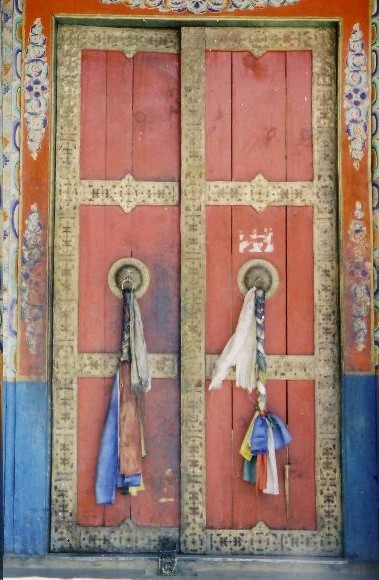
Temple Door at the Monastery at Thikse, Ladakh.

Statue of Maitreya, the Future Buddha, at Thikse Gompa. This statue, 2 stories high (15 metres) in it’s own temple was completed in 1981.
I have to begin this post with a caveat; it is quite possible that one or more of these photographs are not actually of Nainital, but perhaps of somewhere else. They are certainly of India, but there is nothing written on the back of the photographs. The majority were my father’s, taken by him on leave during the 1940’s, and since he died a long time ago I can no longer question him.
Nainital means the ‘eye lake’, and refers to the goddess Parvati. According to legend, her eye fell into the lake when Lord Shiva, her husband, carried her body back to their home on Mount Kailash.

This first one is a postcard I bought on my visit to Nainital in 2005. Normally, you expect a postcard today to be a picture of as good a quality as possible, so I was delighted to find this one. I have no idea how old the original would have been, but I would guess that it dates from the inter-war period.

This one was taken by my father (or so I assume – another caveat, I suppose!) since it was amongst the ones I inherited from him.

This one I believe is of Nainital, although I cannot work out any details of either the direction it was shot, or the buildings down the hillside. Someone who knows Nainital (Rajiv?) might be able to help me with this one.

Snow View, Nainital. The back of the postcard is blank, and so again I have no idea how old it would be. Google is no help, either. I found two other copies of the postcard, but neither told me anything about the picture.
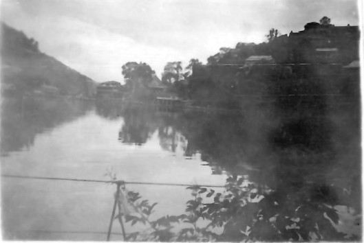
A view across the lake.

And a view of some pretty serious recreational boating.

My father indulging in some of this recreational boating.
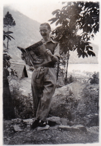
Finally, a photograph of one of his army mates. Although I have no idea who the subject is, I really like the photograph.
Digging into my (admittedly rather small) old postcard collection, I came across a few picturing Darjeeling.

On this first one, other than the title, there is no information on the card. It is unused (as are the other two here), so I do not even have a postmark to help me guess what date the picture was taken. I would guess, however, that although the postcard was probably printed in the 1930’s, the photo could be ten or twenty years older than that. It looks as though the road on the right is The Mall, and the one running from left to right a little way below the skyline could be Hill Cart Road. Looking through a magnifying glass, it is possible to see that there are plenty of pedestrians, but I cannot make out a single vehicle. The photo would have been taken from a high spot on Dr Zakir Hussein Rd, near where the TV tower now stands.

The second one is simply labelled ‘Native Village, Darjeeling’, and is the representation of a hand-tinted black and white photo. ‘Darjeeling’ is much more than the town, of course, and covers a large area all around it. Other than that, I could not hazzard more than a guess where this village lies. Searching through a few internet sites, however, I found another copy of this with a date of 1910.

Finally, ‘The Railway Loop above Tindharia, Darjeeling’. Also hand coloured, this particular picture appears to be a copy of a photograph taken in 1880 by Bourne and Shepherd. Also known as ‘Agony Point’, this was built to enable trains to tackle the steep gradients by spiralling around instead of going straight up or down. It is renowned for being an incredibly tight loop.
Perhaps this is also a good place to slip in a link to my previous blog post:
My First Long Trip to India (5) in which I wrote about my impressions of Colonial era India when I visited Darjeeling for the first time.
In today’s alternative ‘Alice in Wonderland: ‘When I use a word,’ Trumpty Numpty said in rather a scornful tone, ‘it means just what I choose it to mean — neither more nor less’.
Lewis Carroll obviously saw this fellow coming.
Just thought I’d share that with you. Anyway, back to the task in hand. After two ridiculously hectic weeks, I now have to do my best to catch up with everything. Onward!
***
I don’t have a business brain.
I look at my clutter of short stories and paintings, my carvings and photographs and think ‘I should be able to at least make a bit of a living out of all of these.’


But I don’t. And then I wonder ‘how on earth I am going to do it?’ and go ‘aaargh!’ and run off into the distance.
It really doesn’t help.
And so, if I had to have made a New Year’s Resolution this year, it would have been to sort all this out. I didn’t, but that doesn’t mean I can ignore it for any longer.
To begin with, then, how about attracting new blog followers?
Dressed in a loincloth and brandishing a spear (not a sight that sensitive readers should try to picture in their minds), I go charging out onto the lightly wooded WordPress plains, hunting new blog followers.
‘Aha, there’s one!’ I think, spotting a potential follower grazing harmlessly beside the River of Inspiration. I sneak up on them, then hurl a ‘follow’ at them, hoping that they will respond in kind.
Er, no.
It’s just not me, unfortunately. As I have mentioned in the past, I find it incredibly difficult to blow my own trumpet. And I will not ‘follow’ someone just for the sake of getting a ‘follow’ back. I do understand that anti-social media make up the platforms I have to work with, but for some reason I have not yet got my head around using them properly. So for blogs, I shall carry on as I always have. I don’t hunt for followers, I let them find me. Then if they follow me, it is presumably because they like what I’m writing.
Of course, they might simply be after a follow in return, but that won’t happen unless I like what their site does.
I do need to be more professional, though. For a start, then, I have begun to properly update the information on each site I use – such as the ‘Author Profiles’ on Goodreads, Amazon and LinkedIn.
So please feel free to connect with me on those sites – Goodreads LinkedIn. I promise I will put up more book reviews on Goodreads, and try to work out just what the hell LinkedIn is for.


I shall sort out the prices on the paintings and photography websites.
What? Oh, Paintings and Photographs – thanks for asking!

And I need to find new ways to promote my novel Making Friends with the Crocodile.
And then, there is this blog. I must regularly update the information on the ‘About’ page and the ‘My Writings’ page.
Do I need to simply be bolder in my approach to all this? Should I put a ‘shop’ on my blog?
I don’t know. But, learning how to properly use the limited anti-social media I reluctantly and sporadically do take part in (other than blogging), is a priority for me.
But I’m damned if I will ever use Twatter, though.
Call me arty. Call me something, anyway.
I’m in the middle of a ridiculously busy couple of weeks, so in place of one of my usual ‘witty’ and ‘well-argued’ posts, here are a small selection of pictures that I recently put up on my Picfair site.
I still don’t even have time to catch up with anyone else, but I will in a week or so. Honest!

Marionettes, masks and puppets in a shop window display.

Arches and columns reflected in floodwaters.
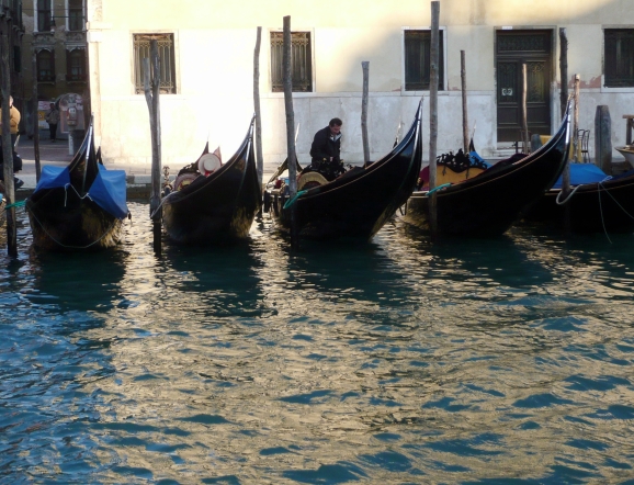
Gondolas. It’s Venice, there have to be gondolas.

Umbrellas. It’s raining. You get umbrellas.

Chairs in a rainy St Mark’s Square.

The Venetian version of a backstreet. Or backwater. Whatever.
