Shorelarking at Rye

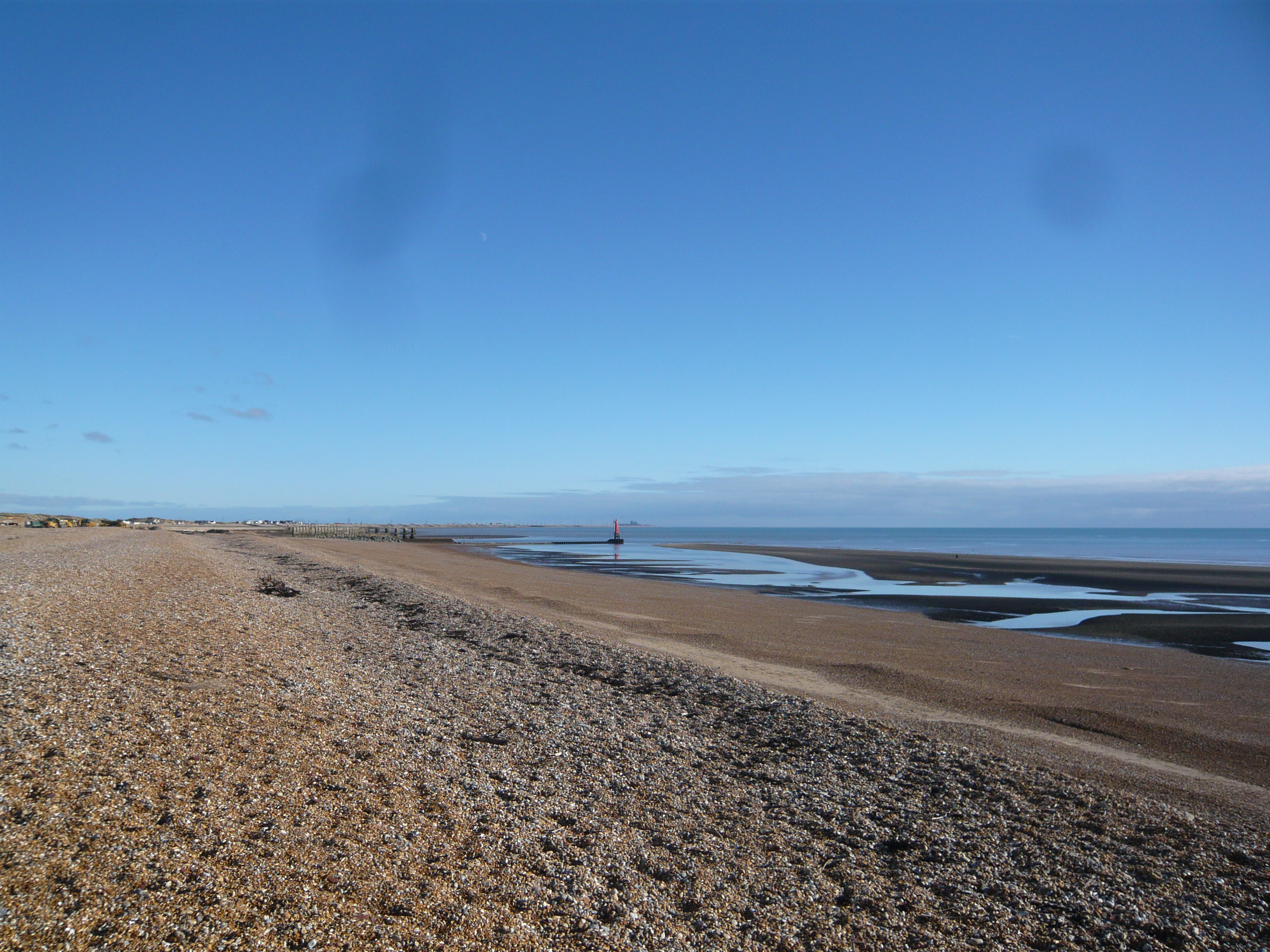
We went down to Rye harbour in Sussex, a few weeks ago, on a beautifully sunny but bitingly cold day. The actual harbour entrance is in the middle distance of the above photo with Dungeness Power Station just visible on the horizon in the distance.

This red-roofed hut sits on the shingle on the approach to the harbour and has become the iconic image that everyone photographs. I resisted the temptation this time, but took this one a few years ago. No one seems certain when it was built, but it was certainly in use from the early 1900’s onwards and was used to store fishing equipment.

The salt marshes behind the harbour constitute a nature reserve and are an important place especially for migrating birds. We walked around the marshes for an hour or so and did see quite a few birds, especially when we spent some while in a hide with the binoculars we’d brought. No close-up photos, because we were too far from the birds and I only had my pocket camera that day, but especially noticeable was was a group of some forty to fifty cormorants.

One of the tasks of the Environment Agency here is to continually move shingle in trucks westwards along the coast to shore up (pun intended) the sea defences. Due to the prevailing winds, longshore drift continually moves shingle eastwards along the coast and without this intervention it would choke the harbour mouth and undermine the sea wall at Pett (to the west). They load up the trucks with shingle from the shore, the trucks drive west and tip it out on the shore. The sea washes it eastwards along the coast again. The trucks load up with shingle from the shore…It almost feels a pointless exercise, but I suppose there’s no real alternative.

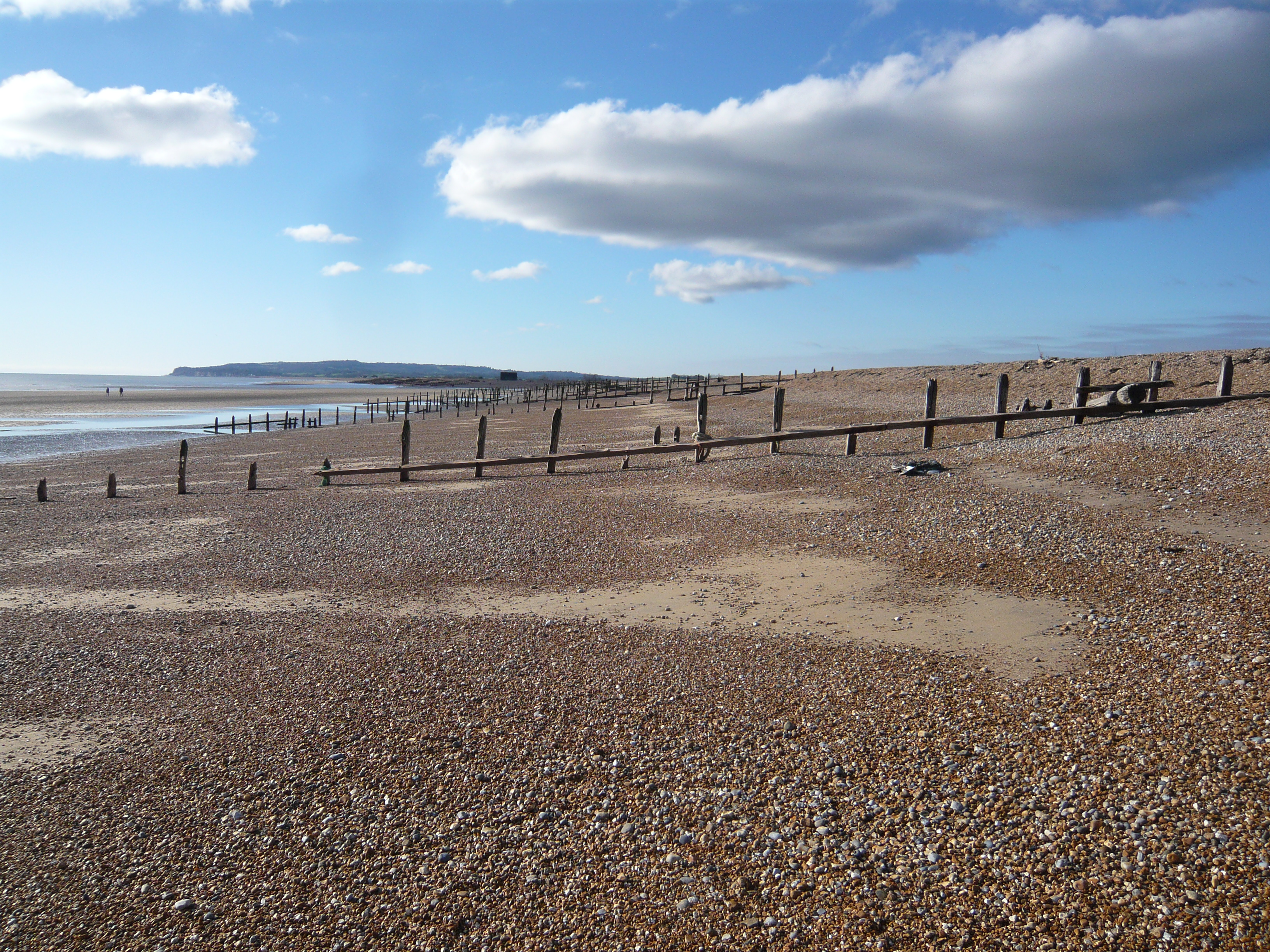
But longshore drift means that the shorelark on the South coast of England has a chance of finding rocks and stones (and all sorts of other things) that originated further to the west, and we spent some while searching among the stones here to see what we might turn up.

Shorelarking? It’s like mudlarking, but on the seashore. ‘Larking’ in this sense means looking for…well, anything. Coins, interesting rocks, anything lost or old or, preferably, both. Not that we found much, not that we ever find much, but we don’t do it as seriously as some folk. And as nice as it would be to turn up the sort of finds some people find in the mud of the Thames, we’re not that dedicated. But in the past I have found bits of flint tool while fieldlarking, and usually come home from a walk with an interesting stone or two.

We did find a couple of interesting things that day – they don’t look much, do they? But the grey stone in the centre is possibly a Mesolithic hammer stone, used for shaping flint tools while the nail had a tiny piece of wood still attached, but this crumbled away as soon as I picked it up. How old is it? I’ve no idea. Nails like that were in use from the 1800’s through into the 1900’s but it’s impossible to pin it down further. My immediate thought was it could be part of the beach groyne, but when I looked they seem to be constructed entirely with rivets. Maybe it is from an old shipwreck. The rock at the bottom is simply a lump of sandstone from further west along the coast, a piece of what was called Hastings Sandstone when I studied geology, but now known as the Ashdown beds. Nothing special, again.

Just an interesting few finds on the beach on a cold sunny day before we headed off for a warm drink.

Qutb Minar

Two or three weeks ago I read Rama Arya’s blog on Qutb Minar and I remarked then that Qutb Minar is probably my favourite place in Delhi and decided I ought to put up a couple of my own pictures, too. It seems to have taken me rather longer to get around to it than I had intended, but here ’tis.

Qutb refers to the whole of the complex, including the tower and several other important buildings. The Qutb Minar itself is a red and orange sandstone tower 72.5m tall. It has a diameter of just over 14m at its base, and just under 3m at the top, and is the tallest tower in India.

A little context: The first of the Moslem invasions of India was by Muhammed, Sultan of Ghur in what is now Afghanistan, in 1192. Is that not wondrous? I’d love to live in a place called Grrr. Having overrun a large part of the Northern Indian plains, he returned to Ghur, leaving his new territory in the hands of his army commander and favourite slave, Qutbuddin Aibak. Qutbuddin decided to leave a monument to his religion that was designed to overawe his new subjects and inspire his own people, and set about building a mosque with a massive tower nearby.

And this is a squinch in Iltutmish’s Tomb. Is not a squinch a wondrous thing also, both in its construct and its name? A squinch is a ‘bridging’ structure, used here to support a dome (now gone). Iltutmish was Shamsuddin Iltutmish (ruled 1211-1236), 3rd ruler of Delhi (after Qutbuddin and Aram).

This is the famous ‘non-rusting’ iron pillar. This stands in the courtyard of the mosque and was here long before the mosque was built. It was made in the reign of Chandragupta II (AD 375-413), is composed of almost pure iron (99.72%) and shows only the slightest sign of rusting. A sanskrit inscription on the pillar indicates that it probably stood originally outside a Vishnu temple, possibly in Bihar, and was moved later to this site. It would probably have had a garuda, the vehicle of Vishna, on the top. 

A close-up of the inscription.

Decorative details of the stonework. Most artistic decoration is, as usual with Islamic craftwork, patterned work and verses from the Koran. At Qutb Minar, there are also plentiful stylised, and sometimes surprisingly realistic, depictions of plants with flowers and buds and long, winding stems and tendrils. To construct the mosque, artisans used stone from Hindu and Jain temples and many stones and panels still depict the original carvings, frequently defaced but still recognisable.

Brahminical motifs on the columns of the Quwwat-ul-Islam Mosque. These pillars were originally part of the Hindu and Jain temples destroyed in the area when Qutbuddin built his capital. It is recorded that twenty seven temples were destroyed. They would have been reassembled by Hindu craftsmen, Qutbuddin using local labour.

Another view of the columns on one of the cloisters surrounding the Quwwat-ul-Islam Mosque.

NOTE: My faithful follower might recognise some of these notes and photos, as this is a rehash of part of a post I wrote on Delhi several years ago. I think it’s worth revisiting, since it’s such a wonderful place.

The Weald of Kent and Sussex

South East England is my area. It is where I was raised and, other than a few years spent abroad, it is where I have lived my whole life. In particular, the Weald and the Downs. Not so much the coastline, which has never particularly attracted me, but the hills and valleys, the woodlands and rabbits, the hidden crags and open downland, the land of streams and foxes and badgers, birds and villages and butterflies.

039a

On the Sussex Downs

There is a curious fact about the wooded areas of South east England, which is that there is more woodland, covering a greater area now, than was the case four hundred years ago.

032a

Back then, South East England was the industrial heartland of Britain. This was before the discovery of the coal seams of the North and the Midlands, and the various factors which would eventually lead to the greatest impact of the Industrial revolution being in those areas.  Instead, the modest iron deposits of the Weald were mined and worked into firedogs and nails, cannon and cooking pans, as the wealth of words such as hammer and forge in place names still bear witness.


037b

Huge numbers of trees were cut down to feed the fires of these forges, and huge numbers also for charcoal burning, for building, and near the coast the great Kent and Sussex oaks were in huge demand to build the large number of ships the navy demanded. But then from the mid eighteenth century onwards, industry began to shift northwards.

Despite the pressures on the land for building and for farming in this crowded corner of our crowded island, there is actually more woodland now than there was during the fifteenth and sixteenth centuries. And that is not something that can be said of many parts of Britain or, I suspect, many parts of the world at all.

010a

The Weald is an area whose underlying rocks are sandstone and clay, which means that the unimproved soils are inevitably either light and sandy or thick and claggy. In some parts there are old sunken tracks known as ‘Summer Roads’, so-called because they became impassable in the winter months, when they might have had a foot or more of thick, wet, muddy, clay on their surface. When these were in use, journeys between villages that might take an hour or two in summer, could became almost impossibly long during the winter.

037x

At the moment, all everything in the news seems depressing and unpleasant and so, this post is an indulgence. Just a smattering of information, and a few photos of places I love, largely to improve my mood.

Bodhgaya (2) – A Special Place

About six months ago, I put up a post on Bodhgaya (which you can find here if you wish to read it again), and promised I would find a few more photos to post another time.

This is another time.

img_0018

My first picture is of the entrance to the Mahabodhi Temple, which is built on the site where the Buddha achieved enlightenment. The first temple was built by Emperor Ashoka, in the third century BC, and the present one was erected in the fifth or sixth century AD. Visitors remove their shoes (or face a one hundred rupee fine) and descend the steps from the garden that surrounds the temple.

img_0020

Just before reaching the entrance itself, they will pass this small chorten – one of dozens surrounding the temple – garlanded with marigolds.

img_0019

Many more chortens surround the temple and can be found around the gardens themselves, these ones beside a carved sandstone balustrade.

img_0024

But the Mahabodhi Temple is by no means the only Buddhist temple in Bodhgaya. As the place where the Buddha attained enlightenment, it has naturally been the focus for many Buddhists from around the world, and there are many other temples built by those from the various different branches of Buddhism. This one is one of two Tibetan temples.

img_0017

On the edge of Bodhgaya, this twenty five metre tall statue of the Buddha was erected in the grounds of the Japanese Daijokyo temple in 1989.

But Bodhgaya, naturally, is more than simply its temples. Although it is quite naturally a major tourist attraction, it is also home to many people, and daily life is not much different from other towns in Northern India.

img_0023

As you approach the temple areas from the northern side of the town, this is a fairly typical scene. In the distance, the share auto that plies between Bodhgaya and Gaya is filling up with passengers, and men and women shop for essentials.

img_0021

A woman carries a basket of dried cattle dung, which will be used to fuel the cooking fire.

img_0022

And on the edge of the town, the scene quickly becomes rural once again.

From Thursday I shall be away for a few days, but will catch up with comments and other blog posts once I am back.